|
|
|
|
|
|||
|
|
autore |
PIER VITTORIO AURELI |
|
|
|
titolo |
THE POSSIBILITY OF AN ABSOLUTE ARCHITECTURE |
|
||
|
editore |
THE MIT PRESS |
|
||
|
luogo |
LONDON |
|
||
|
anno |
2011 |
|
||
|
|
|
|
||
|
lingua |
INGLESE |
|
||
|
|
|
|
||
|
Titolo originale: The possibility of an absolute architecture |
|
|||
|
|
|
|||
|
Argomento e tematiche affrontate |
||||
|
|
In this book, Pier Vittorio Aureli proposes that a
sharpened formal consciousness in architecture is a precondition for political,
cultural, and social engagement with the city. Aureli uses the term absolute
not in the conventional sense of “pure,” but to denote something that is
resolutely itself after being separated from its other. In the pursuit of the
possibility of an absolute architecture, the other is the space of the city,
its extensive organization, and its government. Politics is agonism through
separation and confrontation; the very condition of architectural form is to
separate and be separated. Through its act of separation and being separated,
architecture reveals at once the essence of the city and the essence of
itself as political form: the city as the composition of (separate) parts.
Aureli revisits the work of four architects whose projects were advanced through
the making of architectural form but whose concern was the city at large:
Andrea Palladio, Giovanni Battista Piranesi, Étienne Louis-Boullée, and
Oswald Mathias Ungers. The work of these architects, Aureli argues, addressed
the transformations of the modern city and its urban implications through the
elaboration of specific and strategic architectural forms. Their projects for
the city do not take the form of an overall plan but are expressed as an
“archipelago” of site-specific interventions. |
|||
|
|
||||
|
Giudizio Complessivo: 8 (scala 1-10) |
||||
|
Scheda compilata
da: Maddalena Riboni |
||||
|
Corso di
Architettura e Composizione Architettonica 3 a.a.2014/2015 |
||||
|
|
||||
|
|
Autore |
|||
|
Pier Vittorio Aureli studied at the Istituto Universitario di
Architettura di Venezia and later at the Berlage Institute in Rottedam. Aureli currently teaches at the AA School of
Architecture in London and is visiting professor at Yale University. He is
the author of many essays and several books, including The Project of
Autonomy (2008) and The Possibility of an Absolute Architecture (2011). Dogma was founded in 2002 is led by
Pier Vittorio Aureli and Martino Tattara. From the beginning of its
activities, Dogma has worked on the relationship between architecture and the
city by focusing mostly on urban design and large-scale projects. Parallel to
the design projects, the members of Dogma have intensely engaged with
teaching, writing, and research, activities that have been an integral part
of the office’s engagement with architecture. Dogma is also active in
offering consultancies to municipalities and agencies concerned with urban
planning and architectural issues. Dogma’s work has been widely published and
exhibited. In 2006, Dogma has won the 1st Iakov Chernikhov Prize for the best
emerging architectural practice and in 2013, on the occasion of the
exhibition ‘Dogma. 11
Projects’the first monograph on the work of the office was published by the AA
Publications. |
||||
|
Pier Vittorio Aureli |
||||
|
|
||||
|
CHAPTERS |
||||
|
Chapter I - TOWARD THE ARCHIPELAGO: defining the political and
the formal in architecture |
||||
|
In the first chapter the author attempt to reconstruct the possibility
of an architecture of the city that is no longer situated only in the
autonomous realm of its disciplinary status, but must directly confront
urbanization. This possibility is put forward in two ways: by critically
understanding the essential difference between the concept of the city and
the concept of urbanization, and by looking at how urbanization has
historically come to prevail over the city. The author starts difining the differences between the
Greek polis and the Roman concept
of civitas and urbs. Then, he argues that with the rebirth of the Western city
after the dissolution of Roman civilization, the "economic impetus"
of urbs gradually took over the
political idea of civitas. Unlike
the Greek polis or the Roman civitas, the origins of which were
essentially political, the rebirth of the Western city at the turn of the
first millennium was propelled by the role of economics. The gradual rise of
the bourgeoisie defined the very identity of the contemporary city. Then, with the advent of the idustrialization and the rise
of the capitalism, the role of the urbs
absorbed the idea of civitas to
the point that over the last three centuries we have witnessed the triumph of
a new form of human association based entirely on the mastery of the urbs: urbanization. Here Aureli analyzes the work of some urbanists and
architects: Ildefons Cerdà, Ludwig Hilberseimer, Le Corbusier, Archizoom
Associati, Rem Koolhaas.
Like Cerdà's idea of
urbanization, Hilberseimer's principle of the plan, and Archizoom's No-Stop
City, Rem Koolhaas's City of the Captive Globe is based on an isotropic
principle and the potential for infinite development, but unlike these models
it has a center (the square of the Captive Globe itself). Koolhaas called his model an
"archipelago"; but the space of the building in Koolhaas's City in
not really that of an island, where the relationship between inside (terra firma)
and outside (the sea) is vital and open to different approaches, but is more
like an enclave. The enclave is a restricted space that makes the urban
territory uneven. The social discrimination
dictated by the selective space of the enclave is based not on politics but
on the total sovereignty of economy in
the form of urban management. Bound to the regime of the economy, this logic
of inclusion/exclusion dissolves the potential dialectical conflict among the
parts of the city, and transforms confrontation and its solution into the
indifference of cohabitation, which indeed is the way of living in
urbanization. To understand the real
meaning of the term urbanization Aureli
introduces and analizes two different concepts : political and formal. Both the concept of the
political and the concept of the formal indicate the possibility of the
composition of difference by assuming the limits of parts as their
constituency. Consequently, both the political and the formal contain the
idea of the whole per via negativa,
by virtue of being absolute parts. To reply the question about
what could be a form of reference for a renewed political and formal
understanding of the city and its architecture, the author introduces Mies
van der Rohe's work; while the urban theories of Cerdà, Hilberseimer,
Archizoom, and Rem Koolhaas are seen as the most extreme paradigmatic
projects of urbanization, the late work of Mies is interpreted as
demonstrating the possibility of an absolute architecture. Mies's late
projects absorbed the reifying forces of urbanization, but presented them not
as ubiquitous but as finite and clearly separated in patrs. The idea of separated parts
links the possibility of an absolute architecture to the idea of the
archipelago as a form for the city. The concept of the archipelago describes
a condition where parts are separated yet united by the common ground of
their juxtaposition. In contrast to the integrative apparatus of urabanization, the archipelago
envisions the city as the agonistic struggle of parts whose forms are finite
and yet are in constant relationship both with each other and with the
"sea" that frames and delimits them. The islands of the archipelago
describe the role of architectural form within a space more and more dominated
by the "sea" of urbanization. In this way, each architectural
invention is bound to a conceptual
continuity that transform the episodic nature of each intervention
into islands of the archipelago. |
||||
|
|
||||
|
Chapter II-THE GEOPOLITICS OF THE IDEAL VILLA: Andrea Palladio and
the project of an anti-ideal city. |
||||
|
If the villa is one of the most radically ideological
architectures because it hides its economic dependency on the city by
claiming self-sufficiency within the countryside, then Palladio's palace-plus-barchesse composition openly signals
the villa's relation with its regional and agricultural economic context.
However we have an alternative interpretation of Palladio's architecture :
reads the villa as one element within a larger, latent project. Rather than
taking Palladio's "ideal" as a model for an equally ideal urban
configuration, it views the geography and politics of the villa as a
framework for rethinking and retheorizing the significance of Palladio's work
as a project for an anti-ideal city. Palladio's approach to the city is based not on an overall urban plan but
on the strong formal continuity and universalism evoked by his classical
references. Yet, in contrast with the Roman city model, Palladio's
universalism is defined by the concrete figure of architecture as a clearly
circumscribed artifact , distinct from the ground
of the city spaces surrounding it. The variety of contexts in which he
operated offered an array of urban situations of various scales in which he
could test the seamlessness of an architectural language against the inexorably fragmented nature of
the city. More than his bridges and palazzos, the villas in the Veneto region are
the most celebrated of Palladio's work. What is impressive about these
buildings is not so much their architectural quality but their quantity; no
other architects has offered a portfolio filled with designs of such
impressive continuity. Palladio assigned the villa a position of exceptional
importance in his Quattro Libri: five chapters of the second book are devoted
to the architectural principles of this type, which is treated with the same
attention to detail as other crucial city types such as palaces and religious
buildings. Palladio's villas are not simply
objects enclosed within a reconstructed context, but are specific objects
that frame and redefine the existing landscape as an economic, cultural and
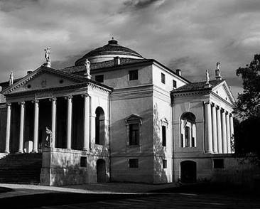
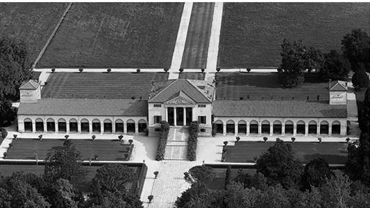
political counter to the city. The Villa Emo in Farzolo(1556) perhaps best shows the radicalism of Palladio's
approach to the relationship between the villa and its immediate landscape.
With the Villa Emo we see the classic Palladian
paradox of a building that has been designed according to its own
compositional logic ( typically based on symmetry), yet at the same time is
also inflected so as to react to its specific site condition. This paradox is
further radicalized in Palladio's most famous building, the Villa Capra, or
La Rotonda (1567); in this building the unity of
city and countryside is further radicalized, as if the building were a kind
of manifesto.
Ultimately, it was in Venice that Palladio finally
seemed able to satisfy his project of the city. His building constructed
there, which are mostly churches, can all be seen against the backdrop of
Venice's economic, geographic and political crises, but more immediately they
relate to two significant proposals for restructuring and preserving the city
in the wake of the Serenissima's demise. The first
was a project by Cristoforo Sabbadino:
develop the borders of the city in the form of a ring of waterfront fondamenta (
large embankments that would enclose and define Venice's forma urbis); the second visionary project, culturally more
complex and sophisticated, was an elaboration by Alvise
Cornaro of the concept of the theatre he had
constructed in his garden in Padua. The shames of both Sabbadino
and Cornaro were designed to expand the city beyond
the limits of its traditional monumental spaces, which until then had been iconographically controlled by the Piazza San Marco. The difference between Sabbadino's
urban project and Cornaro's vision is that while Sabbadino aimed at the consolidation of the existing
city, Cornaro imagined a new Venice that radically
invested architecture by stressing the analogy between the singularity of the
architectural artifact and the insularity of the
city form. Both project, however, were united in introducing an urban theme
that is key to Palladio's monumental interventions in Venice: the idea of the
urban edge not just as city form but also as a new monumental space linking
the city to its territorial context; in other words, there is a link between
the idea of the edge( as introduced by the project of both Sabbadino and Cornaro) and the
physical location of all Palladio's Venetian buildings. In order to fully understand Palladio's analogical
Venice, we need to go back to his earliest failed assault on the city and the
first of two proposals he made for a new Rialto Bridge(1556). In this project
Palladio programmatically established an approach to the city that is
anything but classical: the bridge is conceived as a civic hub made up of two
parallel rows of shops spanning the Grand Canal; in the second vision of the
project Palladio focused only on the bridge, at its centre he placed a
classical square. Palladio's unique architectural approach sought to
establish a characteristically modern dialectic between the absoluteness of
architecture and the openness of the city; using forms and typologies to effect
contextual relationships and political visions, he fundamentally reimagined
not only the physical manifestation of the city but its
very idea. Palladio looked to the ancient monuments of Rome not
simply as sources for the correct interpretation of the orders, but as
complex organisms that reproduced the rich architectural qualities of a city.
It was for this reason that he studied the model of the roman bath; Palladio
viewed the bathhouse as a unique public structure because it grouped together
multiple programs and activities. The same spatiality is evoked in Palladio's
building by introducing a ground-floor portico ; by incorporating public
spaces, Palladio's buildings were not simply outstanding examples of
architecture, but exemplars of an architectural relationship to the city. It is this explicit will to
idealize that made Palladio's collective series of buildings the absolute
embodiment of a project for the city. |
||||
|
|
||||
|
CHAPTER III - INSTAURATIO URBIS: Piranesi's Campo Marzio versus Nolli's Nuova
pianta di Roma. |
||||
|
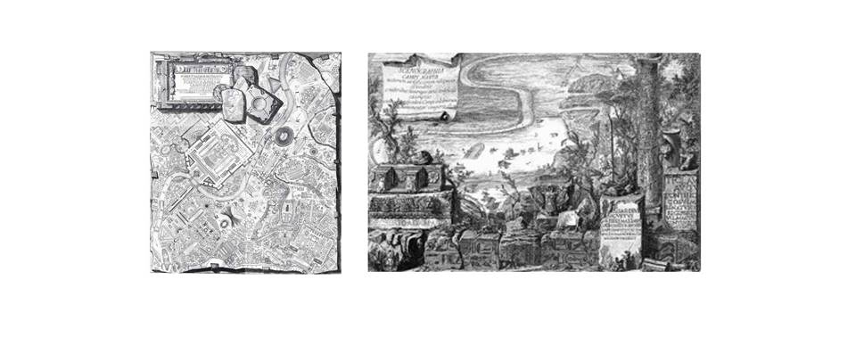
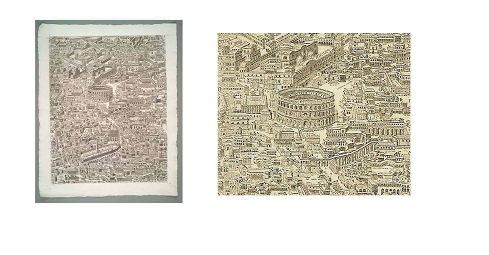
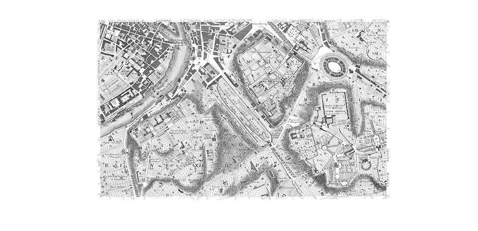
Within the history of project for cities, no image for a "new city" is as radical as the Scenographia Campi Martii, engraved by Giovanni Battista Piranesi. In
the Scenographia, Piranesi presents an image of Rome
in which several existing ruins from its imperial past stand in a desolate
landscape. This engraving simply depicts the few surviving ruins of
Piranesi's day: the ruins are not restored but are represented in their
current condition. Here the ruins can be read both as what have survived the
subsequent development of the city and as the conceptual guide for the
reconstruction of a new city. His Scenographia thus
condenses three seemingly conflicting action( destruction, restoration and
reconstruction of the city) into one representation.
Here the author introduces the concept of Instauratio urbis: the
attempts to restore the form of ancient Rome, beginning in the fifteenth
century. After the fall of the Roman Empire, the city contracted in size to
the area of the Campo Marzio along the bend of the
Tiber river. Most of the ancient Mirabilia in the eastern part of the city were abandoned; for centuries
the ruins of this monuments were depicted as objects floating in open fields.
This situation was still visible in Leonardo Bufalini's
map of Rome; the map depicts a dialectical city whose form is made by the
juxtaposition of two conditions: the modern city, with its figure-ground
relationship between monuments and the organic fabric of the city, and the
ancient city with its monument completely liberated from their urban
framework. This urban composition is unique. In comparison, in the Campo Marzio, Piranesi displaces the
urban fabric that for centuries characterized the eastern part of the city to
the site of the modern city: the Campo Marzio. In
the Scenographia, he envisions the destruction of
modern Rome as a precondiotion for a new Rome,
designed throw the restoration of its ancient form. The link between this two
Romes is the few extant ruins, which Piranesi
selected for the introduction to his topographical reconstruction of the
Campo Marzio. Piranesi's Campo Marzio
can be considered the summa of a vision of the city that developed between
the fifteenth and the eighteenth centuries: Instauratio urbis, which literally means "the
installment of the city" and in practice
involved the reconstruction of the ancient form of the city. The implicit
project of many Instaurationes urbis was
the liberation of the ancient ruins from the modern city that had developed
around them. One of the most impressive attempts in Instauratio urbis is Pirro Ligorio's Antiquae Urbis Imago(1561).His reconstruction
of ancient Rome is the most direct precedent for Piranesi's Campo Marzio. In Ligorio's Imago, Rome appears as a city almost
without streets and crowned by objects. The Imago is the most radical representation of a city whose form is
embodied in the composition of its buildings rather than dictated by an
overall plan.
Because ancient Rome was an accumulation of
individual complexes without an overall plan, any attempt at Instauratio Urbis began with careful topographic
siting of the ancient ruins. Why did the ancient form become such a topical drive
in the development of the city for at least three centuries? Interest in
ancient ruins was motivated not by an abstract respect for heritage but
rather by its political instrumentality, which often coincided with the
desire to refound and reconstruct the city. The
motivation of Instauratio Urbis reveals the ideological ground
zero for the revival of antiquity that has been called the Renaissance. A fundamental architectural aspect of the
sixteenth-century Roman surveys was the analysis of monuments within their
topographic locations, just as the Mirabilia Urbis Romae guidebook envisioned ancient buildings as
related to their positions in the space of the city. Instauratio Urbis offered an interpretation of architectural form radically
different from the one inherited from architectural treatises. Especially in
treatises made in the sixteenth-century, the understanding of the ancient
architecture focused on the use of the five orders. Yet in the several phases
of Instauratio Urbis the knowledge of architectural
form was defined more by the individual form of each artifact
in relationship to its topographical position in the city than the use of
orders. Moreover, the survey of ancient monuments made clear to architects
that the variety of compositional orders was irreducible to Vitruvius's
rules. The Instauratio Urbis
was often depicted in the form of city map in which the form of the city was
represented as an archipelago of monuments. By the seventeenth century Instauratio Urbis was no longer in vogue as an urban strategy. In the
difficult geopolitical situation in Europe (conflict between Lutheran and
Catholic) work on antiquity survived mostly as field of study rather than a
political tool but the seventeenth century was also when Rome assumed its
definitive form: as its number of inhabitants increased it saw its
residential areas grow, causing the city to develop a more dense urban
fabric. In the mid eighteenth century, the cultural prestige
of Rome suffered a further blow as a result of its depiction in Diderot e D'Alambert's Encyclopedie. The culture of Enlightenment challenged antiquarian
erudition with the idea of archaeological knowledge. Ancient ruins were not
simply evidence of a past to be preserved, but were also formal examples to
be recomposed according to the narrative of power. Distinct from this
analogical reconstruction of the past, archaeology was embraced by the
Enlightenment as a scientific reconstruction of the past; cartography arose
as a fundamental manifestation of scientific knowledge in the urban culture
of seventeenth and eighteenth centuries. Within the evolution of cartographic knowledge
archaeology advanced as the principal mode of scientific investigation of the
ancient world. For this reason, the Instauratio Urbis was
now begun in the name of scientific accuracy. The new cartographic surveys
and the new wave of interest in antiquity were now perceived not only within
the framework of humanist erudition but also within the new scientific ethos
of cartographic research. Nolli's Nuova Pianta di Roma must be considered in this context.
This map was the first rigorous scientific survey of Rome.
Nolli's map depicts not only the plans of the major
monuments such as churches but also atria, stairs and courtyards of both
major and minor buildings. Open spaces and the ruins ancient Rome are also
mapped. Besides the topographic precision, the Nolli
map is characterized by the figure-ground technique which distinguishes the
architectural features from the rest of built space. While the plans of
church interiors, palace atria and courtyards are drawn as pochè excavated within built mass, the remaining built
mass is rendered as "building" footprints filled with a linear
hatch. The figured ground distinction that Nolli
introduced has often been discussed as symbolising the difference between
public and private space, but such an interpretation is incorrect. In fact it
symbolises the difference between architectural space and urban space. In Nolli's representation of the relationship between
architectural space and urban space, the first one no longer appears to
propel change in the city, but instead frames such change as an obstruction
to the all-encompassing forces of urban space. Architectural space is defined
by its internal logic, while urban space appears determined by the external
constraints of the built mass and is thus not reducible to an univocal form
like architecture. Observing Nolli's
representation of the city, and especially of architecture, one can argue
that Piranesi's embrace of the Instauratio Urbis project
was not motivated only by his desire to defend Roman architecture against
claims for the superiority for the Greek architecture. Rather, the tenets of
Piranesi's idea of Rome could be seen as a reaction to the idea of the city
implied of Nolli's map. Piranesi's method of
surveying the city and reconstructing its form can be read as a critique of
the urban epistemology that the Nolli map
exemplified. Piranesi recuperated the formal thinking of the Instauratio Urbis as an ideological reading of
the city. It seems that Piranesi realised the unconscious project of Instauratio Urbis when he moved the ancient ruins
from the empty landscape to the center of the
modern city: the Campo Marzio. Moreover inspired by the scientific methodology of
topographic survey, Nolli had approached the
reconstruction of ancient Rome as an archaeological problem based on found
evidence and devoid of intuitive conjecture or any argumentative thesis other
than the need to make the entire topographical form of ancient Rome
scientifically legible. Piranesi radically contradicts this approach
suggesting that the restoration of the true form of the ancient Rome is
possible not by relying on mere evidence or by attempting an overall survey
of all the topographic layers of the city, but by focusing on the remaining
ruins and using them as points of entry for a conjecture about the form of
the city. The Nolli map illustrates
the difference between architecture as finite form and a city as a totality
of urban space, which he represented with a diagrammatic blackened mass. This
demonstrated that architecture is simply an island within the city, whose
urban form far exceeds the possibility of an architectural morphology to
accommodate its scale. The conjecture of Piranesi's forms confirms the
unbridgeable discrepancy between architectural form and the totality of urban
space. |
||||
|
Chapter IV- ARCHITECTURE AS STATE OF EXCEPTION: Etienne-Louis
Boullèe's project for a metropolis |
||||
|
Architecture, Essay on Art
(written at the end of the eighteenth century by Etienne-Louis Boullèe but unpublished until 1953) can be understood as
an architectural treatise in the form of commentary of a series of public
monuments that Buollèe designed between the last
years of the French Monarchy and the years immediately after the 1789 Revolution.
All of the projects were characterized by austere composition of simple
volumes. Boulèe's use of the term monument is important: before Boulèe,
monument were used to describe a commemorative building; after him, the
monument also included any public building housing a public service, such as
theatre, library or museum and potentially accessible to all. Boulèe distinguish the monument from residential
architecture which was defined as "private", or not accessible to
all. Boulèe's monument addressed and celebrated its use by the anonymous and free
individual; thus a library is a monument to the "science", a museum
is a temple to the culture. Boulèe's public
monuments shared an architectural language based on the composition of
anonymous and simple geometrical volumes. These volumes were characterized by
two kinds of partitions: bare walls and densely arranged columns that seems
to form walls. Boulèe's work is exceptional in its exclusive use of public monuments as a mean
for a generally theory of architecture and because these monuments respond to
specific site and technical condition. He had established a few logical principles trough which it was possible
to address any design problem; These principles were the idea of composition achieved
through the paratactic juxtaposition of simple geometrical forms, the use of
natural effects such as the play of light and shadow and the distributive
clarity of a building. Architecture, Essay on
Art was based on the invention
of a few exemplary architectural composition which, by repeating certain
principles, had the potential to define a general approach to architecture. Boulèe's principles were a reflection on architecture not only as an autonomous
discipline but also as a project on the city; his project was not a
revolutionary negation of the existing architectural tradition, but rather a
critical post revolutionary appropriation of this tradition for addressing
public space. Architecturally, French classicism represent the rise of a systemic
architecture and urban design that developed in parallel with the
consolidation of the nation-state's sovereignty and the emergence of the noblesse de robe as the new ruling
class. French classicism was a style of public representation based on the
diffusion of canons and formal simplification; it designated an approach more
inclined toward norms than exception, toward regularity rather than
complexity. Blondel's Cours d'architecture (1675)
is an example of the systematic diffusion of architecture as an espirit de systèm
based on strict rules and proportion. The same way of thinking is found in
the theories of Claude Perraud. A fundamental
political contribution to diffusion of this classical language was the
creation in 1671 of the Acadèmie Royal d'Architecture by Louis XIV's minister of finance,
Jean-Baptiste Colbert. This evolution of architectural pedagogy based on attributes such as
clarity, austerity and the combinatory logic of form would serve as the
foundation of the Boulèe's simple forms. Yet Boulèe's monuments would transform this attributes from
their normative control of the city into an archipelago of finite formal and
spatial states of exception. The three most powerful form of architecture and urbanity that were
inspired by the systematic language of French classicism were the courtyard,
the square and the axis; these took the respective forms of the hotel, place and boulevard. It is precisely within the context of a new spatiality, born from the
tradition and typologies of French classicist architecture and evolved
through the urban transformation of the landscape as a site of production,
that architects increasingly diminished the role of the classical orders and
decorations in favour of the free composition of volumes in the landscape. Boulèe's formal vocabulary must be seen in this context. Here the composition of
volumes in a landscape is not simply assumed and theorized as a necessity,
but it emphasized as holding the possibility for architecture to emancipate
itself from mere utility and to become a form of critical judgement. The composition of simple volumetric forms is the central theme of Boulèe's theory of architecture. If we understand Boullèe's sequence of monumental public buildings as a
"project for a metropolis", this project can be seen as an
archipelago of architectural states of exception that counter a metropolitan
space dominated by the extensive management of production. When Boullèe was working in Paris, before the
Revolution, the metropolis was envisioned as a sequence of singular spaces;
after the Revolution, the metropolis had become a vast complex of movement
and transactions that exceeded any finite place. The metropolis could be
represented as an open landscape, an extensive scene. This was precisely the
setting of Boullèe's metropolitan buildings. The best example of Boullèe's conception of
architecture in terms of its public access and circulation is his project for
a Coliseum. After the Revolution Boulèe proposed
the Coliseum as a place for public festivals at which an enormous mass of
citizens could celebrate the "national well-being". The main form
of the monument is its accessibility, any other aspects was redundant,
because what matters architecturally in a coliseum is the movement of masses
of citizens and the spectacle of these masses sited in the tribunes. In its absolute formal symmetry and sameness the Coliseum sublimated its
urban context. Indeed, Boulèe strategically placed
this gathering and exhibition of a crowd within the heart of the emerging
territorial metropolis: the Etoile at the top of
the Champs Elysèes. Together with the bare walls, the assembling and staging of the crowd is
thus the analogical figure par excellence in Boulèe's
metropolis, achieved through two fundamental architectural principles:
symmetry and sameness of formal elements. Symmetry is used as a compositional
logic that guaranties the building's maximum legibility. Boulèe developed the principles of symmetry and uniformity as states of
exception in the form of singular monuments that strategically punctuated and
thus opposed the endlessness of the emerging metropolis. For this reason Boulèe's architectural
projects, like Pallodio's villas , can be seen as
analogous cities that through their finite exemplary objects, stage and define
the features of an emerging urban paradigm: the modern metropolis. |
||||
|
Chapter V– THE CITY WITHIN THE CITY: Oswald Mathias Ungers, OMA,
and the project of the city as archipelago. |
||||
|
In 1977 a group of architects launched a rescue project called
Berlin as an Green Archipelago. Led by Ungers, the group incuded Rem
Koolhaas, Peter Riemenn, Hans Kollhof and Arthur Ovaska. To these architects,
the problems of postwar West Berlin provided a potent model of city within th
city, or in Ungerr's terms a city made by islands. Berline fragmented reality provided Ungers with a basis for
interpreting the city as an entity no longer reliant on large-scale urban
planning but rather
composed of islands, each of which was conceived as a formally
distinct micro-city. Ungers developed his theory of the city as an
archipelago, shrinking the city to points of urban density as a way to
respond to the dramatic drop in West Berlin population. Berlin
as a green Archipelago in one of the very few projects in the history of city
planning to address an urban crisis by radically shifting the focus from the
problem of urbanization to that of shrinking the city. This project proposed
a paradigm that went beyond modernist and postmodernist references and that
even today is not fully appreciated for its provocative logic. The
intellectual exchange between Ungers and OMA was one of the most interesting lines of
research about the city in the 1970s. This exchange was based not only on the
collaboration between Koolhaas and Ungers on key project, but also on their mutual interest
in the development of the "third way" to address the project of the
city. Both sought to move beyond the impasse represented by modernist city
planning and the incipient postmodern deconstruction of any project of the
city. The
central focus of this chapter is to reconstruct Ungers's
project as an attempt to define the architecture of the city as invested in
architectural form. In his projects, Ungers
articulated the limits and finitude of architectural form as possible cities
within the city, as a recovery of defining traits of the city, such as its
inherent collective dimension, its dialectical nature, its being made of
separate parts, its being a composition of different forms, within the urban
crisis that was affecting may cities in the late 1960s e 1970s. Two
of the most exemplary flagship projects were the Stalinallee
in the East, by Hermann Henselmann and the Hansa Viertel Interbau in the West, by key figures incuding
Alvar Aalto, Walter Gropius and Oscar Niemeyer. It
may have been the search for a third way, beyond this two directions, that
motivated Ungers's early attempts to outline his
principles for the projects of the city. These principles was first
formulated in series of urban projects (1960s): Colonie
Neue Stadt, Colonie Grunzug Sud and Berlin Markisches Viertel. Ungers's approach in
these projects was explicitly polemical. Their rational monumental form was
intended as a critic of the late modernist praxis of designing the city
through the generic application of given building standards. The main
principle within these proposals was the conception of new housing complexes
not as a generic extension of the city but as clearly formalized city parts.
Ungers defined his Neue Stadt
project as the archetype for a city of negatives and positives (that is a
city in which experience of form as a composition of built and void space
became the main architectural motif). He allied the same approach to the Markisches Viertel complex in
Berlin. In both the buildings Ungers accepted the
building technology and typological standards that were given for these
housing complexes, but he altered their formal composition in order to
recuperate the possibility of monumental form within the peripheral spaces in
which they were inserted. The articulation of simple architectural
volumes to compose and frame complex sequences of spaces assumes a radical
form in what can be considered Ungers's canonical
urban design project: Colonie Grunzug
Sud; this project can be seen as Ungers's critic of one of the most emblematic
alternatives to late-modernist urban design: the megastructure. Ungers conceived the project as a gradual transformation of the site based on a
systematic morphological rereading of its somewhat ordinary form. This approach did not rely on mimetic contextualism but adopted a vocabulary of abstract and
austere architectural forms. What Ungers
extrapolated from the existing city fabric were the most abstract
architectural elements found in the sequence of open and close places. The
rhythms of walls and the seriality of housing
facades. These formal elements were transformed into austere composition of
new housing, through which the late
urban text of the site was made legible. Ungers's city within the city was not the creation of an idyllic village as
opposed to the fragmentation of the city, but an attempt to reflect the
splintering form of the city form within the architectural artifact itself. Between 1963 and 1969 Unrgers taught at the Technical University of Berlin;
here Ungers introduced design experiments based on
a systematic reading of the city. Ungers saw Berlin in its most critical form: a divided city composed of
irreducibly divergent parts and a state of permanent incompletion. Ungers found an archetype for this situation in Schinkel's project for the Havellandschaft,
where he had proposed a landscape of architectural events that involved the
entire area of the river without subsuming it within an overall geometrical
composition. His interventions took the form of an archipelago in which
architecture was juxtaposed with the natural setting. Schinkel
developed his public work as point compositions of an autonomous block freely
arranged within the space of the city. Following this reading of the city and
employing the method Ungers used for Grunzug Sud, his students
produced systematic morphological and geographic surveys of Berlin in which
the systematically analysed the infrastructure of the city. These layers of
Berlin were viewed as disruptive forms that divided the city into parts.
Rather than trying to solve the crisis of the city, the projects proposed
with this method sought to exploit them as the thematic form of the project
itself. The common basis for all this projects was
point interventions: instead of being made with an overall plan, the project
for Berlin was made through the design of radical urban architectures that
envisioned the development of the city as the eruption of radical forms of
metropolitan living. The best representation of this method came
not from Berlin but from London. In the late 1960s, chafing against Archigram's dominant pedagogy at the Architectural
Association, Elia Zenghelis,
a teacher at the AA, introduced the students in his unit, among them Rem Koolhaas, to Ungers's work. In 1971; Koolhaas
decided to visit the Berlin wall. His description of the architecture of the
wall is similar to Ungers's compositional logic for
Grunzug Sud. It was precisely the "ordinary"
architecture of the Berlin wall that suggest to Koolhaas
how even the most imposing artifact, once deployed
in a real situation, loses its purity as a unitary form and becomes a
sequence of very different situation. Koolhaas
elevated the Berlin wall as a representation of how architecture was more
likely to provoke discontinuity than unity. Such an approach to the city become the
conceptual bases for Koolhaas's Delirious New York, which uses the
most critical urban condition as the bases for a city project. In following
this link between Ungers and the early work of Koolhaas and Zenghelis, we can
see the fundamental development of Ungers's city
within the city concept as the germ of Koolhaas and
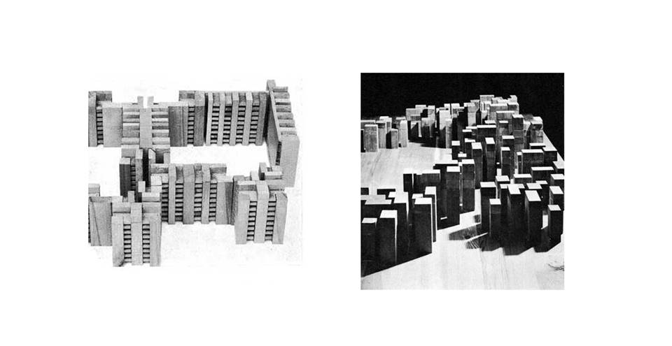
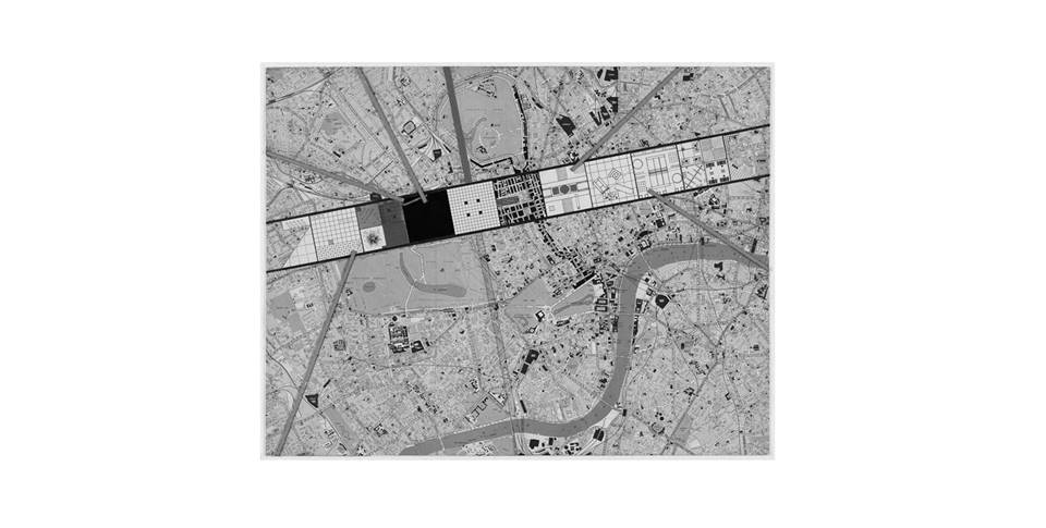
Zenghelis's Exodus, or the Voluntary Prisoners of
Architecture (1972).
Ungers, after encountering Koolhaas, showed great
admiration and interest. For Exodus amplified a theme already emergent in Ungers's work: the principle of turning the splintering
forces of the metropolis into architectural form that addresses the
collective dimension of the city. Ungers had already begun to elaborate a more overtly political approach in the
research topics he initiated upon moving to the United States in 1969. He
became interest in historical examples of communal life in America. Ungers began to research these communities for possible
social and political clues that would support his idea of the city as a field
of delimited form. These studies led Ungers
to believe that developing an idea of the city as an archipelago of limited
parts was more feasible than attempting to realize an overall project like
those of modernist architects. This idea was confirmed by Ungers's
research on the superblock (ex. Karl-Marks-Hoff, Vienna). An increasingly political understanding of the
city as an archipelago was triggered by two events: one, Ungers's
encounter with Koolhaas and Zenghelis
in 1972, and the other his confrontation with Colin Rowe's Collage City. Rowe invited Ungers
to Cornel because he assumed that Ungers idea in
architecture and urban design were involving in a direction similar to his bricolage approach. But it was precisely Ungers's recognition of the fundamental difference
between Rowe's project and his own that helped him to radicalize his approach
to dialectic city. In Rowe's idea of the city difference is
reduced to a morphological exercise: the incremental accumulation of
differences; it was precisely against of this idea of urban design that Ungers developed his own method. This method is
elaborated in two urban design proposal Tiergarten Viertel and Lichterfelde. In
these projects the design invention consists of the formation of city parts
around the contemporary forms of public and collective spaces. OMA's early work can be considered part of the
development of ideas and projects that would lead Ungers
toward Berlin as a Green Archipelago. Koolhaas began his research for his book Delirious
New York studying with Rowe and Ungers, but he
immediately realised that his own position had much more affinity with Ungers explicit adherence to the reality of the city than
with Rowe's nostalgic approach. For both Ungers and OMA,
the potential of the city is generated by its most critical urban forces. The
starting point of Berlin as a Green Archipelago was the urban crisis of 1960.
Ungers and his collaborators considered the crisis
of a declining population not as a problem to solve but rather as the very
engine of the project. Berlin as a Green Archipelago promoted the demolition
of abandoned zones so that the project could focus only on the few selected
part of the city where residents were staying. These parts of the city in the
form of islands would composed a Green Archipelago. While the islands were
imagined as the city, the area in between was intended to be opposite: a
world in which any idea or form of the city was deliberately left to its
dissolution. Ungers's architectural islands in Berlin as a Green Archipelago can be considered
both as self-referential entities and as city parts that frame what escapes
legibility: the inescapable sea of urbanisation. Berlin as Green Archipelago
postulates a city form that requires confrontation whit the opposite
(urbanization) and with the most controversial aspects of the city, such as
division, conflict and even destruction. The city within the city is thus not only
the literal staging of the lost form of the city within the limits of
architectural artifacts; it is also the possibility
of considering architectural forms as a point
of entry toward the project of the city: architecture is not only the
physical object; architecture is also what survives the idea of the city. |
||||
|
||||